An important drilling project on the Englebright Reservoir in California represents a significant advance in the collection of core samples for environmental assessment. This type of study will gain in societal significance as efforts are made to address environmental situations that have no easy solutions.
DOSECC (Drilling, Observation and Sampling of the Earths Continental Crust) is a not-for-profit corporation, and its mission is to provide leadership and technical support in subsurface sampling and monitoring technology for addressing topics of scientific and societal importance. Fifty-four research organizations are members of DOSECC.
This particular project was a multi-disciplinary investigation of the feasibility of introducing anadromous fish species (typically salmon) to the Yuba River system upstream of Englebright Dam in California. Englebright Lake is a narrow, 9-mile-long reservoir completed in 1941 for the primary purpose of trapping sediment derived from mining operations in the Yuba watershed.
Possible management scenarios include lowering or removing Englebright Dam, which could cause the release of stored sediments and associated contaminants, such as mercury used extensively in 19th-century hydraulic gold mining. Transport of released sediment to downstream areas could augment existing hazards, including flooding and mercury bioaccumulation in sport fish.
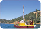
To characterize the depositional history, extent, grain size and chemistry of this sediment, a coring campaign was done with the DOSECC GLAD200 rig on Englebright Lake. Thirty holes were drilled at seven different locations along the longitudinal axis of the reservoir, recovering 20 complete sequences of post-reservoir deposition and progradation. The total length of sediment recovered was 1,250 feet, with 83 percent average recovery.
Sediment accumulation varied in thickness and grain size: 20-25 feet dominated by silt near the dam; 100 feet of layered silt and sand in the middle of the reservoir, and 75 feet of sand and gravel at the site farthest upstream. These cored thicknesses match those from a map derived by differencing the present-day lakebed surface, and the pre-dam topography of the river valley.
Subsampling of the cores for grain-size analysis, mercury concentration, and sediment provenance studies have been underway. The large sediment load of the Yuba River system provides a high-resolution record of fluvial transport and depositional events in an anthropogenically disturbed tributary of the Sacramento River.
ND
Report Abusive Comment