Continuous Process
Ground water systems are dynamic and adjust continually to short-term and long-term changes in climate, ground water withdrawal and land use. Water-level measurements from observation wells are the principal source of information about the hydrologic stresses acting on aquifers and how these stresses affect ground water recharge, storage and discharge. Long-term, systematic measurements of water levels provide essential data needed to evaluate changes in the resource over time, to develop ground water models and forecast trends, and to design, implement and monitor the effectiveness of ground water management and protection programs.The U.S. Geological Survey (USGS) has collected water-level data for more than 100 years, and many state and other agencies have a long history of water level monitoring. However, water level monitoring in the United States is fragmented and largely subject to the vagaries of existing local projects. A stable, base network of water level monitoring wells exists only in some locations. Moreover, agency planning and coordination vary greatly throughout the United States with regard to construction and operation of water level observation networks and the sharing of collected data.
For many decades, periodic calls have been made for a nationwide program to obtain more systematic and comprehensive records of water levels in observation wells as a joint effort among USGS and state and local agencies. O.E. Meinzer described the characteristics of such a program over back in 1935:
"The program should cover the water-bearing formations in all sections of the country; it should include beds with water-table conditions, deep artesian aquifers and intermediate sources; moreover, it should include areas of heavy withdrawal by pumping or artesian flow, areas which are not affected by heavy withdrawal but in which the natural conditions of intake and discharge have been affected by deforestation or breaking up of prairie land, and, so far as possible, areas that still have primeval conditions. This nationwide program should furnish a reliable basis for periodic inventories of the ground water resources, in order that adequate provision may be made for our future water supplies."
More recently, the National Research Council (in 2000) reiterated, "An unmet need is a national effort to track water levels over time in order to monitor water-level declines."
Getting Organized
This report reviews the uses and importance of data from long-term ground water level monitoring in the United States. It is hoped that this report will provide a catalyst toward the establishment of a more rigorous and systematic nationwide approach to ground water level monitoring -- clearly an elusive goal thus far. The time is right for progress toward this goal. Improved access to water data over the Internet offers the opportunity for significant improvements in the coordination of water level monitoring and the sharing of information by different agencies, as well as the potential means for evaluation of water level monitoring networks throughout the United States.Hydraulic Head
Hydraulic head (often simply referred to as "head") is an indicator of the total energy available to move ground water through an aquifer. Hydraulic head is measured by the height to which a column of water will stand above a reference elevation (or "datum"), such as mean sea level. A water level measurement made under static (non-pumping) conditions is a measurement of the hydraulic head in the aquifer at the depth of the screened or open interval of a well. Because hydraulic head represents the energy of water, ground water flows from locations of higher hydraulic head to locations of lower hydraulic head. The change in hydraulic head over a specified distance in a given direction is called the "hydraulic gradient."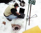
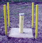
Aquifers
Two general types of aquifers -- unconfined and confined -- are recognized. In unconfined aquifers, hydraulic heads fluctuate freely in response to changes in recharge and discharge. Water levels measured in wells completed in the upper part of an unconfined aquifer help define the elevation of the water table, which is the top of the saturated zone. In confined aquifers, sometimes known as "artesian" aquifers, water in the aquifer is confined under pressure by a geological body that is much less permeable than the aquifer itself. Water levels in tightly cased wells completed in confined aquifers often rise above the elevation of the top of the aquifer. These water levels define an imaginary surface, referred to as the potentiometric surface, which represents the potential height to which water will rise in wells completed in the confined aquifer. Many aquifers are intermediate between being completely unconfined or confined.Ground water levels are controlled by the balance among recharge to, storage in, and discharge from an aquifer. Physical properties such as the porosity, permeability and thickness of the rocks or sediments that compose the aquifer affect this balance. So, too, do climatic and hydrologic factors, such as the timing and amount of recharge provided by precipitation, discharge from the subsurface to surface water bodies and evapotranspiration. When the rate of recharge to an aquifer exceeds the rate of discharge, water levels or hydraulic heads will rise. Conversely, when the rate of ground water withdrawal or discharge is greater than the rate of ground water recharge, the water stored in the aquifer becomes depleted and water levels or hydraulic heads will decline.
Water levels in many aquifers in the United States follow a natural cyclic pattern of seasonal fluctuation, typically rising during the winter and spring due to greater precipitation and recharge, then declining during the summer and fall owing to less recharge and greater evapotranspiration. The magnitude of fluctuations in water levels can vary greatly from season-to-season and from year-to-year in response to varying climatic conditions. Changes in ground water recharge and storage caused by climatic variability commonly occur over decades, and water levels in aquifers generally have a delayed response to the cumulative effects of drought.
Human Activities
Superimposed on natural, climate-related fluctuations in ground water levels are the effects of human activities that alter the natural rates of ground water recharge or discharge. For example, urban development, deforestation and draining of wetlands can expedite surface runoff and thus reduce ground water recharge. Agricultural tillage, the impoundment of streams and creation of artificial wetlands can increase ground water recharge. Long-term water level monitoring during periods of significant land-use change is important to the protection of aquifers. The effects of such human-induced changes on ground water recharge and storage often are incremental, and the cumulative effects may not become evident for many years.The withdrawal of ground water by pumping is the most significant human activity that alters the amount of ground water in storage and the rate of discharge from an aquifer. The removal of water stored in geologic materials near the well sets up hydraulic gradients that induce flow from more distant parts of the aquifer. As ground water storage is depleted within the radius of influence of pumping, water levels in the aquifer decline. The area of water level decline is called the cone of depression, and its size is controlled by the rate and duration of pumping, the storage characteristics of the aquifer and the ease with which water is transmitted through the geologic materials to the well. The development of a cone of depression can result in an overall decline in water levels over a large geographic area, change the direction of ground water flow within an aquifer, reduce the amount of base flow to streams, and capture water from a stream or from adjacent aquifers. Within areas having a high density of pumped wells, multiple cones of depression can develop within an aquifer.
It is important to identify and understand the natural and human-induced stresses on aquifers and the relative and combined effects of each on ground water levels. This will strengthen the primary point of emphasis -- that ground water level data must be collected accurately and over periods of sufficient time to enable the proper development, management and protection of the nation's ground water resources.
Next month, we'll examine observation well selection and quality assurance of measurements.
Report Abusive Comment