Through computer analysis of crosshole seismic and resistivity data, tomography produces a 3-D rendition of the subsurface. The level of detail possible depends upon the distance between holes, the power of the source and the properties of the rock or soil mass. The method can be used for both indurated and nonindurated geomaterials.
Borehole Viewing
And Photography
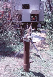
The interpretation of subsurface conditions solely by observation, study and testing of rock samples recovered from core borings often imposes an unnecessary limitation in obtaining the best possible picture of a site’s subsurface geology. The sidewalls of the borehole from which the core has been extracted offer a unique picture of the subsurface where all structural features of the rock formation still are in their original position. This view of the rock can be important, particularly if portions of rock core have been lost during the drilling operation and if the true dip and strike of the structural features are required. Borehole viewing and photography equipment includes borescopes, photographic cameras, television cameras, sonic imagery loggers, caliper loggers and alinement survey devices.Borehole Camera
And the Borescope
Borehole film cameras that have limited focus capability are satisfactory for examining rock features on the sidewalls of the borehole. However, the small viewing area and limited focus reduce the usefulness in borings that have caved or that have cavities. They are best used for examining soft zones for which core may not have been recovered in drilling, for determination of the dip and strike of important structural features of the rock formation and to evaluate the intrusion of grout into the rock mass. The camera’s film must be processed before the images can be examined. The borescope, basically a tubular periscope, has limited use because of its small viewing area, limited depth and cumbersome operation. It is relatively inexpensive to use, however.Television and
Sonic Imagery
The television camera has variable focus and is suitable for examining the nature and approximate dimensions of caving sections of open boreholes or boreholes filled with clear water. The television camera provides both real-time imagery and a permanent record of the viewing session. The sonic imagery (televiewer) system uses acoustic pulses to produce a borehole wall image and can be used in a hole filled with drilling mud. The television camera is used to examine cavities in the rock such as solution voids in calcareous formations, open cooling joints and lava tunnels in volcanic rocks, mines, tunnels and shafts. Most television systems are capable of both axial (downhole) and radial (sidewall) viewing. The televiewer can be used to distinguish fractures, soft seams, cavities and other discontinuities. Changes in lithology and porosity also may be distinguished. Specially designed borehole television cameras and sonic imagers or televiewers can be used to determine the strike and dip of discontinuities in the borehole wall.Alinement Surveys
Alinement surveys often are necessary if the plumbness and/or orientation of a hole is important. Older methods employed a compass and photograph system which was relatively easy to use. More modern systems are electronic.Alinement surveys may be critical in deep holes where instrumentation packages are to be installed or where precise determinations of structural features in the rock formation are required.
Report Abusive Comment