
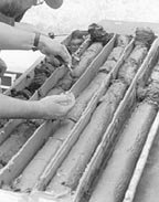
It is low tide. The driver maneuvers the craft easily from open water across a mud flat and comes to rest on a slightly higher sand bar. The motor is shut down, a small auxiliary power plant is started and drilling commences on a site that could not be reached by boat, truck, or foot. As the drill rods are advanced, the driller measures and records the amount of cumulative compaction occurring with each run until the depth of refusal is reached. Then the core barrels are systematically retrieved and the core, safely inside plastic sleeves, is logged, capped, and taped to preserve the sediments and the pore water. The whole process might take a little less than an hour for a single, thirty-foot core hole.
Addressing modern environmental drilling problems requires new techniques for acquisition of geologic information. The technology and experience exists to drill and recover continues cores from unconsolidated deposits. However, studies of modern deposits require drilling in environments difficult to access including deltas, marshes, beaches, and river bars. Various push tubes, hand augers, or vibrator-powered tools are of marginal effect in consistently recovering complete sequences of complex sedimentary deposits. The United States Geological Survey (USGS) is now challenged to document human impact on sedimentation rates, and nutrient and contaminant cycling through surface and groundwater systems. Analysis of groundwater flow systems and estuaries are important strategies of defining flow and storage of materials through natural systems. Comprehensive geologic data about modern, Holocene, and Pleistocene deposits are required for climate history and environmental studies.
Continuous cores of surficial and shallow submerged deposits commonly preserve evidence of sea level rise, salinity change, and land use changes. We need the capability to cut and recover continuous cores to depths of 30+ meters from saturated, unconsolidated deposits, rapidly, with minimum mobilization time between holes.
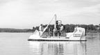
We have found that we can obtain the requisite subsurface information by combining the emerging technology of multi-sonic drilling and amphibious qualities of a trailerable hovercraft. The hovercraft enables us to go where evidence of recent sediment transport and deposition is stored. The multi-sonic drill cuts and retrieves continuous, undisturbed cores from a wide variety of saturated and unsaturated materials. The cores recovered by this tool provide not only the stratigraphic history of modern sediments, but also time-constrained geochemical and geotechnical information applicable to a variety of environmental issues. The information this craft can generate will help define the parameters of publicly volatile issues including habitat of pfiesteria colonies, contamination of shallow aquifers, groundwater de-nitrification, sediment transport and deposition.
Based on our experience producing cores for geologic research, we have determined undeformed, uncontaminated cores from soft sediments are best obtained with a multi-sonic core drill. The unit selected for this project is the Meta-Drill, manufactured by NDA member MPI Drilling of Picton, Ontario. The "Meta-Drill" employs hydraulically driven cams that generate high frequency vibrations at the cutting edge of a hollow drill string.
A core can be cut or a monitoring well installed rapidly with almost no cuttings. No fluids are used or injected into the ground. This is particularly important if uncontaminated samples are required. Drill spoil that must be removed from environmentally sensitive sites is minimized. Cores cut with the Meta-Drill can be extruded into a tray or core box and sampled immediately, or they can be kept in sealed plastic tubes.
The integrity of insitu pore fluids can be maintained and oxidation of organics or sulfides can be minimized. The Meta-Drill is rated to cut and recover 100 feet (30 meters) of 3-inch core with NQ rod. At this time, our longest core recovered has been 65 feet with nearly 100 percent recovery. We have found it possible to use 3-inch threaded PVC (schedule 80) pipe for holes less than 30 feet deep. This provides savings in cost and weight.
The hovercraft used for this project is made by Hovertechnics of Benton Harbor, Michigan. This is the largest version of their "Hoverguard" series. It is 21 feet long, 8 feet wide, and weighs about 4,000 pounds with the drill mounted. We can trailer this craft over the road between sites. The craft has been strengthened to carry the extra weight of the Meta-Drill and it has been equipped with a drilling well in the center. This craft rides on a cushion of air and has successfully lifted 2,000 pounds of drill, people, and equipment. On smooth surfaces, it can travel in excess of 30 miles per hour. With its large surface footprint, (approximately 24,000 square inches), its distributed weight on a marsh surface is about 0.16 pounds per square inch, less than a large heron, muskrat or duck!
A Chevrolet 350 C.I.D. vortex engine powers the Hoverprobe. The fuel-injected engine drives two 40-inch, 12-blade ducted fans through newly designed Goodyear clog belts with chevron-toothed pulleys. The 40-inch fans provide lift and forward thrust. Hydraulically powered vanes are used to adjust the lift and thrust to meet changing demands of varying terrain.
This high performance vessel requires high maintenance. Keeping it clean and serviceable while operating in muck implies constant attention to detail. Moreover, operating in marginal, hard-to-reach sites requires careful planning and support to recover cores and other vertical data that satisfy project needs. Recognizing these requirements and the limitations of wind, waves, slope angles and surface roughness, this tool can provide data for defining and characterizing recent geologic history of dynamic environments with uncommon precision.
While developing a drilling protocol in the Chesapeake Region, we have recovered 40 foot and 65 foot cores from tidal marshes and estuaries, participated in pioneering insitu, real time, groundwater monitoring guided by parallel cores, produced many cores that capture the stratigraphic record of agricultural and land use history, and just recently, we have cored mountain slope deposits underlying a bog on top of the Blue Ridge Mountains in Virginia.
Cores recovered by the Hoverprobe 2000 are providing a three-dimensional, stratigraphic framework for characterizing flux, storage, and alteration of sediment, nutrients, and contaminants stripped from contributing watersheds and deposited into lakes and estuaries.
In Summary
The new Hoverprobe 2000:
- * Allows routine access for vertical sampling of remote, shallow modern deposits.
- * Allows recovery of continuous core through entire deposits (as deep as 90 feet).
- * Allows for drilling without fluids and produces almost no cuttings, reducing the potential for contamination of sensitive or hazardous sites.
- * Produces uncontaminated core that can be isolated from oxidation, dehydration, and light.
- * Facilitates multi-level water quality samples without permanent well installation.
- * Facilitates interpretation of framework, processes, history of wetland, lakes, and estuaries.
- * Facilitates implementation of monitoring strategies that replicate natural systems.
Report Abusive Comment